


Muskoka: The Ultimate Hiking Destination with Stunning Hiking Trails For All Skill Levels
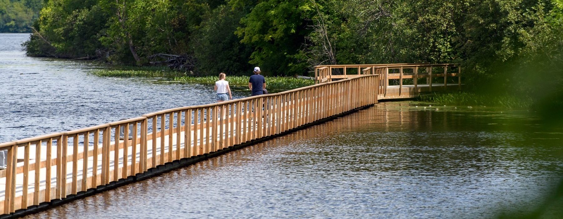
Muskoka is known for its stunning landscapes and natural beauty which offers a wide variety of hiking trails catering to all skill levels. Whether you’re seeking a leisurely stroll or a more adventurous trek, Muskoka has something for everyone. Muskoka also offers you well maintained trails situated on some of Ontario’s most beautiful lakeside, waterfalls, and forested locations. From popular in-town trails and waterfalls to quiet out-of-the-way islands, Muskoka’s trails are waiting to be explored! So Lace up your hiking boots and explore these popular hiking spots in the region:
Click here to see a map of Muskoka’s trails, including directions on how to get there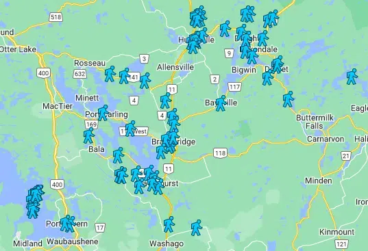
Trails in each township listed below:
Huntsville, Ontario is a beautiful area for hiking, with its stunning natural landscapes and numerous trails that cater to hikers of all skill levels. Here are some popular hiking destinations and trails in and around Huntsville:
- Algonquin Provincial Park: Located about 45 minutes north of Huntsville, Algonquin Provincial Park offers a wide range of hiking trails, from short walks to multi-day treks. Some popular trails include the Lookout Trail, Booth’s Rock Trail, and the Track and Tower Trail.
- Limberlost Forest and Wildlife Reserve: This privately owned reserve near Huntsville offers a network of trails through a diverse forest ecosystem. The Limberlost Reserve Trail is a popular choice for hikers and is known for its scenic beauty.
- Arrowhead Provincial Park: Located just north of Huntsville, Arrowhead Provincial Park features several hiking trails, including the Stubb’s Falls Trail, Big Bend Lookout Trail, and Mayflower Lake Trail. The park is known for its beautiful scenery and opportunities for wildlife viewing.
More Trails to Explore:
Hunter’s Bay Trail – on Hunter’s Bay off Centre St North, Huntsville – Difficulty: Easy – Length: 6.8km
Lion’s Lookout Trail – on Lookout Point Rd, Huntsville – Difficulty: Easy – Length: 1.5km
Fairy Vista Trail– Grandview Forest Hill, Huntsville – Difficulty: Easy – Length: 3.4km
Beaver Meadow Trail – Arrowhead Provincial Park – Difficulty: Moderate – Length: 7km
Big Bend Lookout Trail – Arrowhead Provincial Park – Difficulty: Easy – Length: 0.8km
Stubbs Falls Trail – Arrowhead Provincial Park – Difficulty: Easy – Length: 2km
Mayflower Lake Trail – Arrowhead Provincial Park – Difficulty: Easy – Length: 1km
Homesteader’s Trail – Arrowhead Provincial Park – Difficulty: Easy – Length: 3km
Huntsville Murals Walk – Main St E, Huntsville – Difficulty: Easy – Length: 2km
Lake of Bays is a picturesque region in Ontario, known for its stunning landscapes and numerous outdoor recreational activities, including hiking. Here are some hiking options in the Lake of Bays area:
- Lake of Bays Heritage Trail: This 16-kilometer trail network takes you through a variety of landscapes, including forests, wetlands, and rocky terrain. It’s a great option for those looking for a moderately challenging hike. The trail offers beautiful views of Lake of Bays and is accessible from several points, including Dwight Beach and Baysville.
- Ragged Falls Trail: Located near the west side of Lake of Bays, the Ragged Falls Trail is a relatively short, easy hike that leads to the impressive Ragged Falls, a stunning natural waterfall. It’s a great place for a scenic walk and some nature photography.
- Dorset Scenic Lookout Tower: The Dorset Scenic Lookout Tower offers panoramic views of Lake of Bays and the surrounding area. While it’s more of a lookout point than a traditional hiking trail, the short walk to the tower provides breathtaking vistas.
More Trails To Explore:
Limberlost Forest and Wildlife Reserve Solitaire lake Trail – on Limberlost Rd S, Lake of Bays – Difficulty: Easy – Length: 5.8km
Baysville Trail – on University St, Baysville – Difficulty: Moderate – Length: 2.5km in each direction.
Echo Valley Nature Trail – on Echo Hills Rd off Hwy 60, Dwight – Difficulty: Moderate – Length: 3.5km
Dorset Lookout Tower Trail – on Dorset Scenic Tower Rd off Hwy 35, Dorset – Difficulty: Easy – Length: 2km
Dwight Beach Trail – on Copper Lake Rd off Hwy 60, Dwight – Difficulty: Easy – Length: 2km
Beetle Lake Trail – on Algonquin Outfitters Rd off Hwy 60, Algonquin Highlands – Difficulty: Moderate – Length: 6km
Frost Centre Trail – off Hwy 35 just before Pine Springs, Lake of Bays – Difficulty: Moderate – Length: 1 – 11km stacked loop
Ronville Hiking Trail – on Ronville Rd off Hwy 35, Lake of Bays – Difficulty: Easy – Length: 1.2km
Bondi Village Resort Trail – on Fox Point Rd, Lake of Bays – Difficulty: Moderate – Length: 15km
Ragged Falls Oxtongue River Trail – on Ragged Falls Park Rd off Hwy 60, Algonquin Highlands – Difficulty: Easy – Length: 1km
Hillside Hamlet Walking Trail – on Tally Ho Rd off Hwy 60, Dwight – Difficulty: Easy – Length: 3.6km
Port Severn Walk – on Port Severn Rd N off Hwy 400, Port Severn – Difficulty: Easy – Length: 3km
School House Trail – on Violet Dr off Hwy 400, Port Severn – Difficulty: Easy – Length: 4km
Cambrian Trail – Georgian Bay Islands National Park – Difficulty: Easy – Length: 2km
Fairy Trail – Georgian Bay Islands National Park – Difficulty: Easy – Length: 2.5km
Rockview Trail – Georgian Bay Islands National Park – Difficulty: Easy – Length: 1.5km
Massasauga Trail – Georgian Bay Islands National Park – Difficulty: Easy – Length: 2km
Dossyonshing Trail – Georgian Bay Islands National Park – Difficulty: Easy – Length: 2.5km
Big Chute Hiking Trail – off Whites Falls Rd, Big Chute – Difficulty: Moderate – Length: 7km
Georgian Trail – Georgian Bay Islands National Park – Difficulty: Moderate – Length: 7km
Treasure Trail – Georgian Bay Islands National Park – Difficulty: Moderate – Length: 3.8km
Christian Trail – Georgian Bay Islands National Park – Difficulty: Easy – Length: 1.5km
Tonch Trail – Georgian Bay Islands National Park – Difficulty: Easy – Length: 1.5km
Huron Trail – Georgian Bay Islands National Park – Difficulty: Easy – Length: 2km
Heritage Trail – Georgian Bay Islands National Park – Difficulty: Easy – Length: 0.6km
McCrae Lake Trail – off Hwy 400, Crooked Bay – Difficulty: Moderate – Length: 14.3km
Living Edge Trail – Six Mile Lake Provincial Park – Difficulty: Easy – Length: 1km
The David Milne Trail – Six Mile Lake Provincial Park – Difficulty: Easy – Length: 0.5km
The Marsh Trail – Six Mile Lake Provincial Park – Difficulty: Easy – Length: 1km
Gravenhurst, Ontario, is a picturesque town located in the heart of Muskoka and offers a variety of outdoor activities, including hiking. While Gravenhurst itself doesn’t have extensive hiking trails within its town limits, there are several nearby trails and parks in the Muskoka region that you can explore:
- Muskoka Wharf: The Muskoka Wharf is an 89 acre celebration of Gravenhurst’s unique and varied heritage. This location offers great dining, shopping, history and heritage and is home to some of our Community’s signature events.
- Leo Heritage Trail: This trail provides an alternate route between the downtown area and Muskoka Wharf.
- Chamberlin Trail: This trail travels through a mixture of hardwood forest, open meadow and picturesque neighbourhoods; from peaceful forests and craggy rock cuts to well-manicured lawns and flowerbeds.
Brydon’s Bay Trail – on Old Portage Rd, Gravenhurst – Difficulty: Easy – Length: 1km
Chamberlin Trail – on Chamberlain Dr, Gravenhurst – Difficulty: Easy – Length: 4.2km
Peninsula Trail – on Steamship Bay Rd, Gravenhurst – Difficulty: Easy – Length: 0.8km
Devil’s Gap Trail – on Muriel Cr, Gravenhurst – Difficulty: Moderate – Length: 4.3km
Old Stone Rd Trail – on Muldrew Lake Rd, Gravenhurst – Difficulty: Moderate – Length: 4.9km
Hahne Farm Trail – on Bethune Dr S, Gravenhurst – Difficulty: Easy – Length: 4.9km
Jevins and Silver Lakes Conservation Trail – Jevins and Silver Lake Conservation Reserve, Gravenhurst – Difficulty: Hard – Length: 9.5km
Cooper’s Falls Trail – on Cooper’s Falls Rd, Gravenhurst – Difficulty: Moderate – Length: 7.3km
Kahshe Barrens Trail – at 1342 Hwy 11 N, Gravenhurst – Difficulty: Moderate – Length: 4.8km
Bracebridge, Ontario, is a charming town in the heart of the Muskoka region, known for its beautiful natural surroundings. While Bracebridge itself doesn’t have extensive hiking trails within town limits, there are several hiking opportunities in and around the area. Here are some notable trails and outdoor destinations near Bracebridge:
- Bracebridge Bay Park: Located in the heart of Bracebridge, Bracebridge Bay Park offers a pleasant place for a stroll along the Muskoka River. It features walking paths and scenic views of the river and the iconic Silver Bridge.
- Wilson’s Falls Trail: This scenic trail is just a short distance from downtown Bracebridge. It follows the Muskoka River and provides picturesque views of Wilson’s Falls. It’s a relatively easy walk suitable for all skill levels.
- High Falls Trail: Located near Bracebridge, High Falls is a beautiful waterfall on the Muskoka River. A short trail allows you to hike to a viewing platform to see the falls. The trail offers an excellent opportunity for nature and waterfall enthusias
North Muskoka Trans Canada Trail – on Old Muskoka Rd, Bracebridge – Difficulty: Hard – Length: 27km
Bracebridge Resource Management Centre Trail – off Hwy 11 N, Bracebridge – Difficulty: Hard – Length: 16.5km
Little High Falls and Potts Falls Trail – on Power Point Rd off Hwy 11 S, Bracebridge – Difficulty: Easy – Length: 1km
Wilsons Falls Trail – on Wilsons Falls Rd, Bracebridge – Difficulty: Easy – Length: 3.6km
South Monck and Covered Bridge Trail – on Covered Bridge Rd, Bracebridge – Difficulty: Moderate – Length: 8km
Muskoka River Walkway – on Ecclestone Dr, Bracebridge – Difficulty: Easy – Length: 1.3km
Kerr Park Trail – on Beaumont Dr, Bracebridge – Difficulty: Easy – Length: 2.5km
Strawberry Bay Point Trail – on Strawberry Bay Rd, Bracebridge – Difficulty: Easy – Length: 5km
Muskoka Lakes, located in the heart of the Muskoka region, is a fantastic area for outdoor enthusiasts with a variety of hiking trails and natural beauty to explore. Here are some notable hiking trails and parks in the Muskoka Lakes area:
- Torrance Barrens Dark-Sky Preserve: This unique natural area is famous for its stargazing opportunities and is designated as a Dark-Sky Preserve. The preserve offers hiking trails with interpretive signs that educate visitors about the region’s distinctive geological features.
- Huckleberry Rock Lookout Trail: This short but rewarding trail is located on Huckleberry Rock, providing spectacular panoramic views of Lake Muskoka. It’s a popular spot for hikers and photographers.
- Hardy Lake Provincial Park: Located near Torrance, this provincial park features a network of hiking trails, including the Hardy Lake Loop Trail. It offers beautiful landscapes with forests, rocky outcrops, and views of Hardy Lake.
Torrance Barrens Main Trail – on Southwood Rd, Torrence – Difficulty: Easy – Length: 3.5km
Torrance Barrens Extension Trail – on Southwood Rd, Torrance -Difficulty: Moderate – Length: 4km
Pine Ridge Trail – on Southwood Rd, Torrence – Difficulty: Moderate – Length: 3.5km
Hardy Lake Provincial Park Trail – off Hwy 169, Muskoka Lakes – Difficulty: Moderate – Length: 8km
Huckleberry Rock Lookout Trail – on Milford Bay Rd off Hwy 118, Muskoka Lakes- Difficulty: Easy – Length: 2.5km
Hazelwood Trail – on Hazelwood Rd, Muskoka Lakes – Difficulty: Moderate – Length: 5km
Cranberry Marsh Trail – on Cranberry Rd, Muskoka Lakes – Difficulty: Easy – Length: 5km
Weir Lake Trail – off Hwy 141, Muskoka lakes – Difficulty: Easy – Length: 3.6km
Skeleton Lake Fish Hatchery Trail – on Fish Hatchery Rd off Hwy 141, Muskoka Lakes – Difficulty: Easy – Length: 1km
The Raymond Trail – on Skeleton Lake 1 Rd off Hwy 141, Muskoka Lakes – Difficulty: Moderate – Length: 7km
Port Carling Mural Walk – on Lock St E off Hwy 118, Muskoka Lakes – Difficulty: Easy – Length: 2.5km
Walkers Point Trail – on Walkers Point Rd, Muskoka Lakes – Difficulty: Easy – Length: 1km
Bala Heritage Walk – on Muskoka Rd 169, Muskoka Lakes – Difficulty: Easy – Length: 4.5km